


Cimarron Surveying & Mapping Co. specializes in the collection, organization, presentation and delivery of spatial data. Based in Oklahoma City, Oklahoma we work throughout North America assisting clients with survey and mapping projects.
We offer a comprehensive range of surveying and mapping services to a variety of client sectors. We are extremely flexible which gives us the ability to modify our services to fit your needs at a moment’s notice. Our approach is to work closely with the client and all parties who may have a special interest, to identify and resolve problems and conflicts in a way that protects the interest of everyone involved.
Pipeline Surveying & Mapping
 PIPELINE SURVEYING & MAPPING is a specialized part of Cimarron’s services. We are experienced in all phases of pipeline construction and have experience with projects ranging all across the United States. Beginning with preliminary routing, staking and mapping, to construction as-builts, we are involved in all phases of the projects. Our employees are Operator Qualified through Veriforce and we are a member of the Pipeline Testing Consortium and ISNetworld.
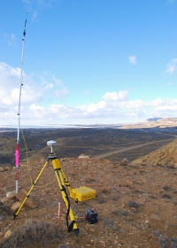
Cimarron has a great deal of experience in GPS surveys for AGM locations and pipeline anomaly staking. We provide an organized booklet containing data sheets that detail each of your AGM’s and follow up by staking out anomalies. If needed, we provide “trackers” during your smart tool runs.
Mapping
 CIMARRON’s MAPPING department utilizes the latest in AutoCAD and other COGO software to produce precision drawings based on the field data collected. We can provide any size or type of drawing you might need. Preliminary, As-built, ALTA-ACSM, Location, Topography and Contours are only some of the types of drawings we are equipped to produce. Call and speak to our mapping department to discuss your specific needs.
- Pipeline Routing & Staking
- Elevations & Sections
- FEMA Elevation Certification
- CAD Drawings & Alignment Sheets
- Site Surveys
- Boundary Surveys
- B.I.A. & Government Land Easements
- Underground Utilities
- Contours
- A.G.M. & Anomaly Staking
- Measured Building Services
- Cross Sections
- Ground Elevation Models
- Volume Computations
- Lease Plans
- Cell Tower Surveys
- ALTA/ACSM Surveys
- Design Surveys
- As-Built Surveys
- GPS Services
- AND MORE…